

Market Update 3/29/2024
Logistics industry market trends you need to know.
GENERAL MARKET TRENDS
POTENTIAL MARKET DISRUPTORS
PORT IMPACTS:
- Francis Scott Key Bridge Collapse: The catastrophic cargo ship crash causing the collapse of Baltimore’s key bridge has led to immediate suspension of vessel traffic in and out of the Port of Baltimore. This disruption, halting export container acceptance, is expected to have widespread ramifications on supply chains and may lead to logistical challenges and shipping delays. Clients should anticipate the need for alternative routing and potential storage solutions in the interim.
- Port of South Louisiana Growth: Exhibiting resilience and growth, the Port of South Louisiana continues to increase its cargo volumes, setting a narrative of recovery and adaptability. Their expansion and record-setting revenue year signal a strengthening of their global shipping partnerships, which could serve as a strategic alternative for rerouting cargo impacted by the Port of Baltimore’s situation. This growth may offer new opportunities for shipping and logistics planning in response to current East Coast disruptions.
- Seagirt Marine Terminal Closure: With the temporary closure of the Seagirt Marine Terminal due to the bridge collapse, one of the Port of Baltimore’s major entry points for cargo processing has been significantly impacted. The terminal’s closure on specific dates will affect freight schedules, and carriers are directed to use alternate gates, possibly resulting in congestion and extended wait times. We recommend clients to plan for these closures and prepare for extended lead times on cargo movement in the area.
- Red Sea-Suez Canal Shipping Disruptions: The ongoing geopolitical tensions and threats of attacks in the Red Sea have prompted significant disruptions in maritime shipping routes, particularly affecting the Suez Canal corridor—a critical chokepoint for global trade. Shippers are being forced to reroute their freight around the Cape of Good Hope or opt for alternative pathways, leading to increased transit times and shipping costs. These developments are critical for clients reliant on timely deliveries, as they may necessitate reevaluation of supply chain strategies to mitigate risks and ensure continuity in operations.
SEASONAL TRENDS:
- Rebuilding Efforts at Baltimore: As we step into April, the focus on rebuilding the collapsed bridge will persist. This event underscores the need for us to anticipate unforeseen disruptions and reinforce our crisis management protocols.
- Spot Rate Trends: April is anticipated to bring about a stabilization in spot rates, with potential for slight increases in specific segments due to the onset of the produce season and increased retail activity. Shippers should stay alert to these trends, leveraging opportunities for cost-effective shipping solutions amidst the evolving market landscape
- Capacity and Seasonal Produce: With the spring produce season ramping up, capacity may tighten in key regions involved in the harvest and transportation of seasonal crops. California, Florida, and Georgia will be hotspots for produce shipping, requiring strategic resource allocation and early engagement with transportation providers to navigate potential capacity constraints effectively
TRANSPORTATION EVENTS:
- International Roadcheck Week (May 14th-16th)
- More information to come regarding safety checks
- CVSA Brake Safety Day is planned, but unannounced
- TIA Conference (April 10th-16th)
UPCOMING HOLIDAYS:
- Easter (March 31)
- End of Ramadan (April 8)
WEATHER IMPACT
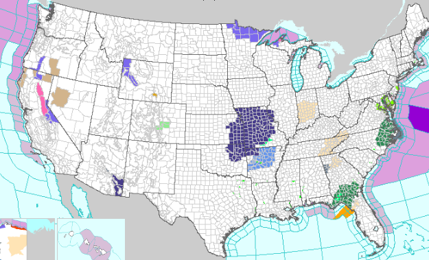
Southeast Coast: Heavy Rain and Thunderstorms:
Timing: Through Thursday afternoon.
Impact: The Southeast Coast is set to experience heavy rain and thunderstorms, with a slight risk of excessive rainfall leading to flash flooding in eastern North Carolina, southeast Georgia, and northern Florida. Marginal risk of severe thunderstorms is also forecasted for the Southeast Coast.
Mid-Atlantic and Northeast Coasts: Rain Showers and Potential Snow Showers:
Timing: Through Thursday.
Impact: Rain showers are expected along the Mid-Atlantic and Northeast Coasts, slight risk of excessive rainfall in southeastern Virginia into northeastern North Carolina. Snow showers may develop over interior New England, with potential for enhanced rain totals in southern New England by Friday morning.
Northwest: Rainy/Snowy Weather
Timing: Started Wednesday.
Impact: A period of rainy and snowy weather is expected across the Northwest, with precipitation spreading and affecting areas from the Pacific Northwest to northern California and the interior Northwest. Significant snow accumulations are possible in the Cascades, Sierra Nevada, and Northern Rockies.
Central U.S.: Warming Trend
Timing: Beginning Today through the weekend.
Impact: A warming trend is forecasted for the Central and Southern Plains into the Midwest, with temperatures expected to be above average.
WPC’s Short Range Public Discussion (noaa.gov)
INDUSTRY NEWS TO KNOW
- State of Freight: Reasons to be bullish on second half of 2024 – FreightWaves
- State of Freight takeaways: Is a weak February the bottom of the cycle? – FreightWaves
- All quiet on the diesel front, for now: Benchmark price up slightly – FreightWaves
- Port Houston shows import strength in February – FreightWaves
- Baltimore port closure puts truck drivers who haul autos in a bind – FreightWaves
- Automakers reroute shipments after Baltimore bridge collapse | Supply Chain Dive
- Port of Baltimore stops accepting export containers | Supply Chain Dive
- Port of Baltimore halts vessel traffic after bridge collapse | Supply Chain Dive
- workers missing in Francis Scott Key Bridge collapse presumed dead – FreightWaves
- Baltimore bridge collapse disrupts traffic, port operations after ship collision – FreightWaves
- Some states urge truck drivers to avoid working during upcoming eclipse – FreightWaves
Like being in the know? Get our biweekly Logistics Market Report delivered straight to your inbox. Sign up here.

