

Market Update 11/30/2023
Logistics industry market trends you need to know.
General Market Trends
Potential Market Disruptors
Port Impacts:
- ‘Dire’ scenario for shipping lines more likely as spot rates fall back (freightwaves.com).
- Recovery not expected until 2025.
- US ports are trending to have a 12.8% year-on-year drop in TEU.
- US ports are estimated to 1.99 million TEUs in Oct and will see a decline in Nov and December to 1.92 million TEUs.
Seasonal Trends:
- Christmas Trees throughout the northwest and other areas.
- After slower than expected start to the Texas crop the yield has now caught up, expect a similar turnout as last year.
- Mexican growers have growing concerns of water as Mexico vegetables show growth in US imports.
- Amazon cites record breaking sales starting holiday season.
Transportation Events:
Upcoming Holidays:
- Christmas (Monday, December 25)
- New Years (Monday, January 1)
- Chinese New Year (Saturday, February 10)
Weather Impact
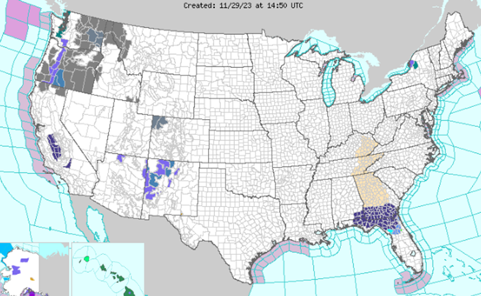
East: High temperatures will once again be chilly and below average by about 15-20 degrees Wednesday along the East Coast and into the South as broad upper-level troughing remains in place over the region. Forecast highs range from the 20s and 30s in New England, 30s and 40s for the Mid-Atlantic into the Carolinas, and 50s and 60s through much of the South outside of South Florida. Frost and freeze-related advisories remain in place from the Florida Panhandle into south Georgia as temperatures Thursday morning may once again dip to near or below the freezing mark, potentially damaging/killing sensitive crops and vegetation. Conditions will moderate Thursday as the upper-level trough begins to shift eastward, with highs 10-15 degrees warmer and much closer to average to close November. Some lingering lake-effect snow showers downwind of Lakes Erie and Ontario should taper off through Wednesday morning, with otherwise mostly dry conditions along the East Coast.
Plains: An upper-level wave passing quickly over the Four Corners and out over the Plains will help to encourage lee cyclogenesis late Wednesday/early Thursday, helping to organize a surface frontal system over the Southern Plains. Some light to moderate rain/snow showers will be possible in the colder air over the Four Corners region Wednesday into Thursday, with a few inches of accumulations possible in the higher mountain elevations. Showers and thunderstorms are expected overnight Wednesday ahead of the system over eastern portions of the Southern Plains and into the Lower Mississippi Valley. Continued very moist southerly flow from the Gulf and increasing shear as the upper-level wave approaches will lead to the threat of severe thunderstorms into the day Thursday over southeastern Texas. The Storm Prediction Center has issued an Enhanced Risk of severe weather (level 3/5) for the threat of a few tornadoes. Storm coverage should continue to expand north and eastward through the Southern Plains into the Lower/Middle Mississippi Valley by later Thursday into the early morning hours Friday. Some locally heavy downpours are expected, with a few isolated instances of flash flooding possible, though dry antecedent conditions in the area should keep this threat limited. Forecast highswill be running in the 50s and 60s from the Southern Plains into the Lower/Middle Mississippi Valley, with 40s and 50s for the Central Plains. Some cooler temperatures will flow into portions of the Central/Southern High Plains following a cold front passage Thursday, dropping into the 40s.
West: Some light coastal showers will be possible from central to southern coastal California Wednesday as a weak Pacific system approaches the coast. Then, a stronger series of systems will approach the Pacific Northwest/northern California by late Wednesday bringing increasing precipitation chances with lower elevation/coastal rain and mountain snow. The precipitation will spread inland into the Great Basin Thursday, with a wintry mix for the interior valleys and snow for the mountains. Some heavier snow accumulations are possible for the Cascades and Sierra Nevada, with some light to moderate snow for other regional higher elevations/mountain ranges. Any accumulations in the valleys should be limited.
Temperatures: Forecast high temperatures more broadly across the West will be in the 30s and 40s for the Great Basin/Rockies/Pacific Northwest, the 50s and 60s for California, and the 60s and 70s for the Desert Southwest. Elsewhere, conditions will be dry across the Northern Plains into the Upper Midwest. Highs will be well above average Wednesday particularly for the Northern Plains, with some temperatures into the 50s possible. Otherwise, highs will generally be in the 30s and 40s.
Industry News
- Labor’s resurgence cannot be overlooked in procurement strategies | Supply Chain Dive
- Holiday inventories remain balanced as shoppers show strength, NRF says – FreightWaves
- Port of Savannah sees fourth-busiest October – FreightWaves
- October cargo volumes decline at Texas ports, rise in New Orleans – FreightWaves
- By the numbers: How retailers stack up on inventory | Supply Chain Dive
Like being in the know? Get our biweekly Logistics Market Report delivered straight to your inbox. Sign up here.


